This article was published as a part of the Data Science Blogathon.
Introduction
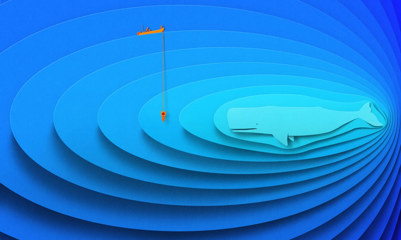
No one wins when a ship arrives at a port with a critically endangered whale wrapped around its bow right beneath the company’s brand logo. Recently, it has been noticed that due to the rapidly transforming ocean ecosystem and deteriorating ocean health, whales often burst through the surface and get killed by giant container ships and vessels. According to scientists, more than 80 endangered whales are killed each year by ship strikes off the West Coast, though only 5-17% of carcasses are recovered as the majority sink to the ocean floor. To circumvent this, the University of California Santa Barbara’s Benioff Ocean Initiative is working with some leading scientists to track whale and shipping activity to devise a tool called “Whale safe” to mitigate the risk of potential whale-ship collisions.
In this article, we will take a look at the proposed methodology. Let’s get right into it now!
 Source: theguardian
Highlights
-
University of California Santa Barbara’s Benioff Ocean Initiative is working with some leading scientists to track whale and shipping activity to devise a “Whale safe” tool to mitigate the risk of potential whale-ship collisions.
-
Apart from sharing the whale data, the tool also displays internationally assigned shipping lanes, voluntary vessel speed reduction zones, and shipping activity deduced from Automatic Identification Systems (AIS).
-
The whale Presence Rating system combines whale sightings (visual observation data), acoustic whale detections (acoustic detection data), and a blue whale model to provide a real-time assessment of whale presence for each region.
-
Speeders can be caught using Whale Safe, and with its assistance, customers can track to see if the cruise they are considering is operated by a company with a history of breaking sea speed restrictions.
What is Whale Safe and How Does It Work?
Whale Safe is a tech-driven mapping and analysis tool that displays whale and ship data in real time. It is designed to circumvent fatal ship collisions with endangered whales. The tool displays acoustic and visual whale detections and a blue whale habitat model that is updated daily per oceanographic conditions. Each day, these three whale data sources are combined to generate an integrated whale presence rating (low, medium, high, very high)
Apart from sharing the whale data, the tool also displays internationally assigned shipping lanes, voluntary vessel speed reduction zones, and shipping activity deduced from Automatic Identification Systems (AIS). Whale Safe also has a reporting system that compiles AIS data to identify which ships and companies best adhere to the voluntary speed recommendations by NOAA to protect endangered whales along the California coast.
The tool’s functionality allows users to sign up for email updates on whale data and whale-safe shipping.
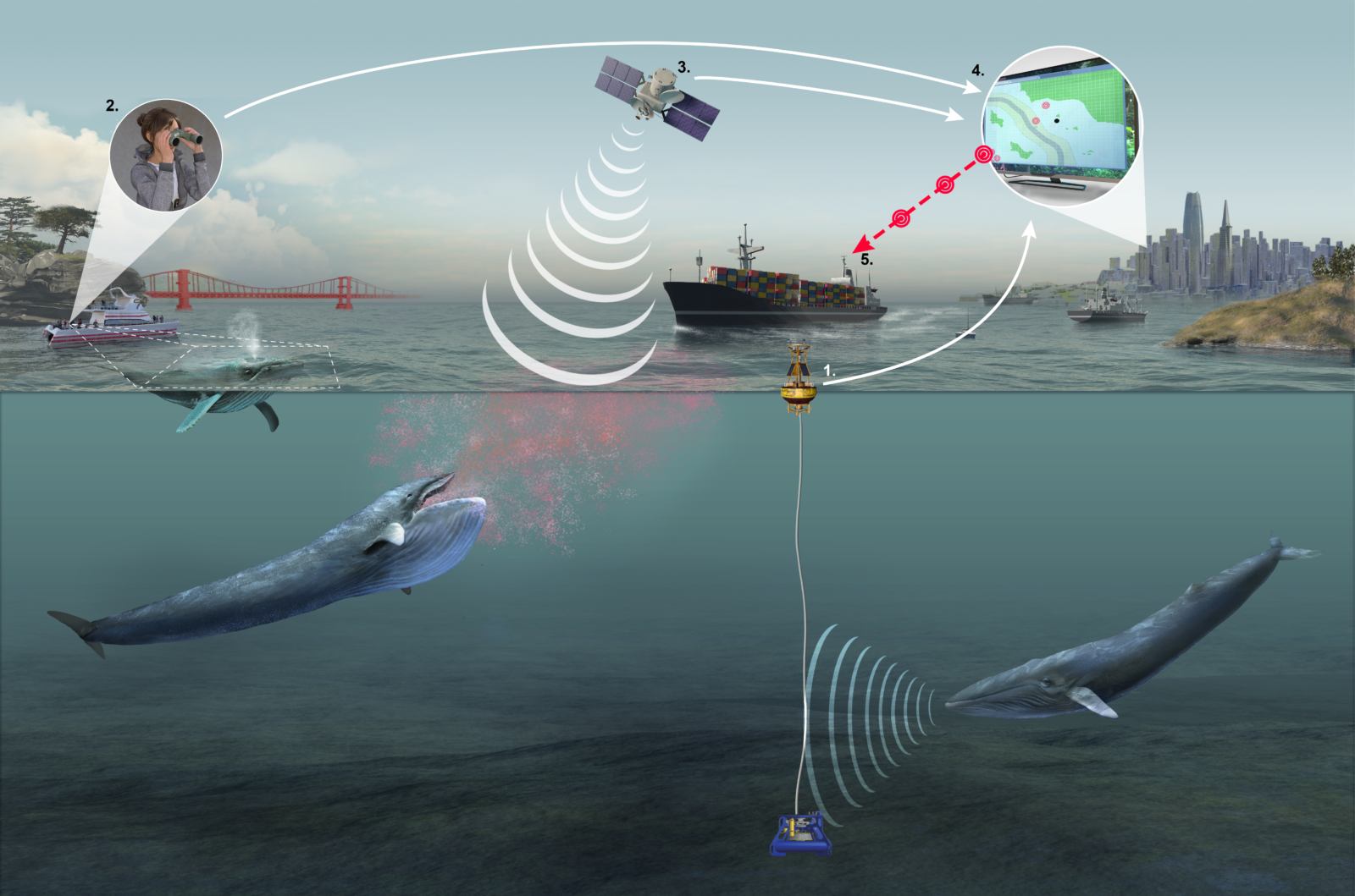
Figure 1: Diagram illustrating the process of determining the presence of whales (Source: baynature)
The procedure for determining the presence of whales is shown in Figure 1. As we discussed before, the Whale Presence Rating system combines whale sightings (visual observation data), acoustic whale detections (acoustic detection data), and a blue whale model to provide a near real-time assessment of whale presence for each region. The following explains the entire process:
1. Acoustic Data Detection: Acoustic monitoring instruments like hydrophone equipped with a tiny computing device is used to detect the vocalizations of blue, humpback, and fin whales.
2. Visual Observation Data: Trained observers record whale sightings aboard tourism boats and whale watches or aircraft with a mobile app. The Whale Alert and Spotter Pro mobile apps are used to record the whales’ location, species, and behavior, which are then transmitted to a database once the boat docks. These observations are combined with information gathered from regular aerial surveys of the shipping lanes in the Santa Barbara Channel.
3. Blue Whale Model: This model utilizes data gathered from 104 satellite-tagged blue whales to link whale presence to environmental conditions (e.g., sea surface temperature, water column properties, salinity, chlorophyll-a, etc.). Then, the model calculates the probability of a blue whale sighting within each 10km x 10km grid cell for the Southern California Bight and San Francisco region based on environmental conditions present the day before.
4. Whale Presence Rating: The above three (1, 2, and 3) near real-time whale data streams are compiled and validated to provide a near real-time assessment of whale presence for each region (See Figure 2). The Whale Presence Rating aims to reduce the risk of ship collisions with endangered whales by offering the shipping industry, natural resource managers, and the general public a simple data-driven assessment of whale presence.
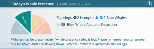
Figure 2: Whale Presence Rating Chart (Source: whalesafe)
5. Whale Information is shared with the public, industry, and managers.
Role of Whale Safe in Stopping Speeding Ships
Whale Safe was tested in the Santa Barbara Channel in 2020. Based on the project’s data, National Oceanic and Atmospheric Administration (NOAA) has issued guidelines according to which large ships are supposed to slow down to 10-12 knots or less when passing through the Santa Barbara Channel and the Greater Farallones National Marine Sanctuary off San Francisco during the whales’ summer feeding season.
Whale Safe analyzes location data broadcasted by ship transponders to determine whether vessels are slowing down and assigns a letter grade that rates companies’ compliance. It also lets the customers track if the cruise they are considering is run by a company with a history of violating sea speed limits. For instance, France’s CMA CGM SA, the third-largest container shipping company in the world, receives data directly from Whale Safe and notifies captains when they need to slow down. Notably, based on the data made public by the Whale Safe group, around 40% of the ship traffic didn’t slow down to 10 knots in both Santa Barbara and Bay Area vessel speed reduction zones.
Impact of Whale Safe
In 2019, five ship strikes of endangered whales were registered in Southern California, and four deaths were reported, including a blue whale that was found wrapped around the bow of a cruise as it arrived at the Port of Long Beach. Later in 2020, the incidents were reduced to two strikes and one death in the first year of the buoy’s operation. Furthermore, last year, the Santa Barbara Channel reported no whale collisions or fatalities.
Challenges Related to this Project
1. More buoys would enable more accurate detection of endangered whales. However, the buoys cost about $250,000 to build and $200,000 annually to operate.
2. Not all whales actively vocalize and make a splash on the surface, eg. gray whales, so the absence of detection doesn’t necessarily indicate that no whales are present. Furthermore, it needs to be noted that the buoy does not provide information on the exact location or number of whales present.
3. Surveys are not constant and are not guaranteed to cross paths with all whales in the regions, so a lack of whale sightings does not necessarily mean that there are no whales present.
Conclusion
To sum it up, in this article, we learned the following:
1. University of California Santa Barbara’s Benioff Ocean Initiative is working with some leading scientists to track whale and shipping activity to devise a “Whale safe” tool to mitigate the risk of potential whale-ship collisions.
2. Apart from sharing the whale data, the tool also displays internationally assigned shipping lanes, voluntary vessel speed reduction zones, and shipping activity deduced from Automatic Identification Systems (AIS).
3. The whale Presence Rating system combines whale sightings (visual observation data), acoustic whale detections (acoustic detection data), and a blue whale model to provide a real-time assessment of whale presence for each region.
4. Using Whale Safe speeders can be caught, and with its help, customers can also track to determine if the cruise they are considering is operated by a company that has a history of violating sea speed limits.
5. Not all whales actively vocalize and make a splash on the surface, e.g. gray whales, so the absence of detection doesn’t necessarily indicate that no whales are present. Furthermore, it needs to be noted that the buoy does not provide information on the exact location or number of whales present.
That concludes this article. Thanks for reading. If you have any questions or concerns, please post them in the comments section below. Happy learning!
Link to Whale Safe’s website: https://whalesafe.com/methodology/
Link to Whale Alert App: https://play.google.com/store/apps/details?id=com.earthnc.whalealert&hl=en_US&gl=US
Link to Spotter Pro: http://conserve.io/spotter-pro
The media shown in this article is not owned by Analytics Vidhya and is used at the Author’s discretion.
I'm a Researcher who works primarily on various Acoustic DL, NLP, and RL tasks. Here, my writing predominantly revolves around topics related to Acoustic DL, NLP, and RL, as well as new emerging technologies. In addition to all of this, I also contribute to open-source projects @Hugging Face.
For work-related queries please contact: [email protected]